Detailed organization profile
Naypyitaw Council
On this page
Published profile
Naypyitaw: location and regional data
Regional map
Location, area and administration
Nay Pyi Taw Council
Nay Pyi Taw happened
1. In 2006, the Union of Myanmar Government and Ministries Since February 17th, 2006, it has moved and opened as the national headquarters. From the cabinet meeting No. (6/2006) held on February 23rd, Kutchone, Don't stop. Since it was allowed to form Pyin Mana District, which includes the remote townships, Mandalay Division, Ministry of Interior, by notification letter dated 16-3-2006. The district was organized into the District of the District and the District of Phinmana, and the Township of Phinmana in the Phinmana District. Khatgone Township, The remote townships participated.
2. The Pyinmana District was established as Nay Pyi Taw District by the notification of the Ministry of Interior dated 29-1-2009, and the townships included in Nay Pyi Taw District were named Nay Pyi Taw Township, Pinmana Township, Khatgone Township, Nay Pyi Taw Township is defined as Lewey Township. Pinmana City The town of Khungone 4 towns and 32 wards 182 village groups have been formed, and the area and boundaries are the former Pinmana District, According to the border.
3. Nay Pyi Taw District, Mandalay Division, which was organized as Nay Pyi Taw District, Nay Pyi Taw Township to Zeyathiri Township, Pabbathiri Township, Uttarathiri Township Jambu Thiri Township and Dakchina Thiri Townships were prepared and organized by the Ministry of Interior's notification dated 26-3-2009.
4. In Nay Pyi Taw district, which was changed and formed, Leway Township, Pinmana Township, Zeyathiri Township, Uttarathiri Township Pabbathiri Township, Zambuthiri Township, Dakhinasiri townships were established by the Ministry of Interior's order notification No. (116/2013) dated 11-1-2013. Zeyathiri Township, Uttarathiri Township Pabbathiri Township, A total of 4 townships were consolidated and organized into Nay Pyi Taw Northern District (Uttar District) and 4 townships, 4 cities Ward 29 88 village groups It is composed of 362 villages. Similarly, Punin Mana Township, Leway Township, Zambuthiri Township, Dakshina Sri Township, A total of 4 townships were organized into Nay Pyi Taw South District (Dakchina District) and 4 townships, 4 cities Ward 25 99 village groups It is composed of 3437 villages.
5. Article 284 of the Constitution According to sub-section (a), Nay Pyi Taw, which is a union territory, includes all the districts and townships within the Nay Pyi Taw municipal boundaries existing on the day the Constitution came into effect, and the Nay Pyi Taw Municipal Development Committee also determined the boundaries of Nay Pyi Taw by Notification No. (45/2011) dated 28-3-2011. Nay Pyi Taw became the capital of the nation under Article 440 of the 2008 Constitution, and under Article 50 Subsection (a) of the Constitution, Nay Pyi Taw, the capital of the nation, is designated as a union territory under the direct administration of the President.
Geographical situation of Nay Pyi Taw
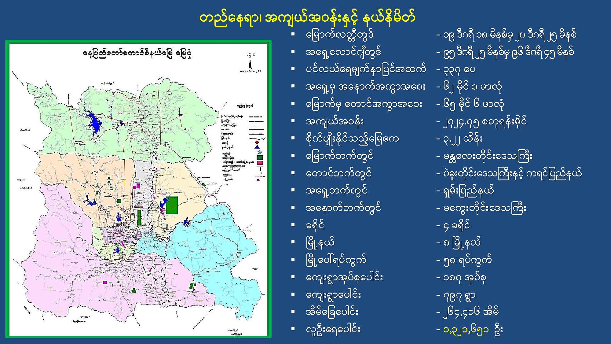
1. Union Territory of the Republic of the Union of Myanmar Nay Pyi Taw is the administrative capital and north latitude19degrees18min between20degrees25minutes; East Longitude95degrees25min between96degrees45minutes; Above the sea between377feet, North from Yangon244miles and south from Mandalay Located188miles; miles west of Pin Laung, the junction of Taunggyi and Loikko100away and east from Magway220miles away. East and West in width57.6miles; South and North86.4miles in area2724.2563square miles; by acres1743844acres. The townships in Nay Pyi Taw are located between the Shan Roma and Bago Roma mountains, an area with equal parts of hilly mountains and flat plains, forests, dams It is a region with many ravines and rivers. Prominent rivers are the Elephant River, Nalai Creek Na Win River stream water stream Kyauk Ma Sing Creek the main stream Manangdi creek, The stream It is a stream that flows from north to south.
2. The entire Nay Pyi Taw region has a hot and humid tropical monsoon climate with the highest average temperature in summer.41.7C and the minimum winter temperature12.2C is there. Average Precipitation Rainy Days76days and rainfall43.13inches.
A Brief History of the Region
3. Union Territory The border area that formed Nay Pyi Taw is the former part of Mandalay Division. Pinmana Township, The borders of the faraway townships were consolidated and the borders of Nay Pyi Taw were determined. A brief history of these townships is as follows:
(a)Khukone Township
. In the history of Burma, before the Bagan period, Nyaung Lunt village is one of the 4 focal areas of the Pyu people in the Tibeto-Myanmar group. During the reign of Anaw Rathamin in the Bagan era, 43 townships were involved. The formation of Khungone Township was established by the Ministry of Interior and Religion's Notification No. (537) dated 5-7-1960. According to the announcements dated 20-1-2011 and 29-4-2011 of the Ministry of Interior, 1 town in the township of Khutgone. Ward 6 49 village groups 176 sub-villages were prepared and organized, and now the Union Territory. Nay Pyi Taw, Included in Uttara district.
( b )Pinmana Township
. Shan traders came down from Lolong Mountain, about 60 miles from Phun Mana, with their oxen, and stopped at a village. The Nglai Creek that runs near the village is only 10 meters wide, so there is a bridge made of mud for cattle and people to cross (or step on) and the place where the people living near that bridge is called Nying Xao. In the olden days, there were many saffron trees in the place where traders used to stay. The name Pin Mana is in the Shan language"Main Moon"seems to be derived from the words'.'- Camp;'Mong'- Fruit;'N'- The door."Main Moon"seems to be called the bitter melon camp. Pyinmana township is a township established by the Ministry of Interior's letter No. 103/50/Min 1 dated 9-11-1972. At that time, Ward 5, 60 village groups 303 villages were formed. Due to the expansion of new townships, the Ministry of Interior's letter no. 200/31 - Ward 5 according to the notice issued by 1 / 1. 30 village groups From the formation of 114 villages, now according to the Ministry of Interior's order No. (847/2013) dated 28-9-2013, 7 wards, 29 village groups It is composed of 140 villages.
( c )Leway Township
. The way Leway Township came about was in the year 191 of Koza, when a person named Maung Nui started to establish it on a hill, so it was originally called (Nga Nuigone City) (Okigone City). After that, it was again named as Bamboo. From the year 1788 until today, it has been called Leway City. The city of Nga Nui Kone, founded by Maung Nui at first, is located at the confluence of the Plawe River and the River Maung River. Because of the time when the city was founded, it is still known as the city hill. It has been learned that the city was founded about 17 years before the beginning of the Bagan era, when Pyin Pia Min ascended the throne. It was found in the history of the district, written by U Maung Maung, the elder of Ngaugkone, that the town of Lewey (Ugukone) was established during the reign of Kyaw Ma Min, the King of the King of Koza in 704. At that time, the surrounding area of (Ngukone) was densely forested, and the farming fields of the people of Ngukone are located in the present Leway Township, so the people of Ngukone who are far away from the fields went to base themselves near the fields and worked on farming, huts, houses After the number of residential houses gradually increased, the township became the headquarters of the township, which became known as Lewey Town. The village of Nui Gone is located in the southwest corner of the city of Lewey as a village called Shigone. Letter No. dated 9-11-1972 of the Ministry of Interior and Religious Affairs as Leway City. 103 / 50 / by the notice issued by (1) and Letter No. dated 28-2-1973 of the Ministry of Home Affairs and Religion to the village groups. 3 / 76 / Order notification letter (2) and dated 28-8-1973 letter no. 3/76/Ut (2) was established by the notice (amendment) and by notice No. (1107/2014) dated 23-9-2014, Ward 7 in Lyway Township. 60 village groups A total of 261 villages were organized. Even
Formation of Nay Pyi Taw Council
1. Security of Nay Pyi Taw, which includes districts and townships within the borders of Nay Pyi Taw Municipal Development Committee for Nay Pyi Taw Administration, which is a union territory; Administration In order to carry out regional development, it is placed under the direct administration of the President and the administrative organization for the Union Territory of Nay Pyi Taw is designated as the Nay Pyi Taw Council. The President of Nay Pyi Taw Council and the members of the Nay Pyi Taw Council were notified by the President's Office dated 26-4-2016. Article 285 of the Constitution with 5 councilors; subsection (b); sub-section (1); Section 21 of the Union Government Law and Section 3 of the Nay Pyi Taw Council Law. Formed in accordance with sub-section (a). Article 260 of the Constitution, Section 3 of the Nay Pyi Taw Council Law According to subsection (c), the head of the Nay Pyi Taw General Administration Department serves as the secretary of the Nay Pyi Taw Council.
What happened in the 2020 multi-party democratic general electionon vote fraud and illegal practices investigation findings Contact
SOURCES & REVIEWSources and how to read them.
Sources and how to read them.
Covers eight directory categories and the portal profiles of all 50 listed organizations, including tables, images and links. Full content of external agency websites and attached documents is outside this scope.
Images are reproduced from the government portal. Text within images has not been translated.
Retrieved by Nagani · 2026-10-18
Government portal source ↗